Natural Communities Commonly Associated with Groundwater (NCCAG) Dataset
Dataset Description
The Sustainable Groundwater Management Act (SGMA) and DWR’s Groundwater Sustainability Plan (GSP) regulations establish new requirements on the elements that Groundwater Sustainability Agencies (GSAs) are to include in their GSPs. One of those requirements is the identification of groundwater dependent ecosystems (GDEs), and where appropriate, impacts on GDEs. GDEs are defined in the GSP Regulations as ‘ecological communities or species that depend on groundwater emerging from aquifers or on groundwater occurring near the ground surface’. Determination of GDEs within a groundwater basin is the responsibility of the GSAs. DWR created the Natural Communities Commonly Associated with Groundwater dataset (hereafter referred to as the Natural Communities dataset), to assist GSAs in the preparation and implementation of GSPs.
The Natural Communities dataset is a compilation of 48 publicly available State and Federal agency datasets that map vegetation, wetlands, springs, and seeps in California. A working group comprised of DWR, the California Department of Fish and Wildlife (CDFW), and The Nature Conservancy (TNC) reviewed the compiled dataset and conducted a screening process to exclude vegetation and wetland types less likely to be associated with groundwater and retain types commonly associated with groundwater, based on criteria described in Klausmeyer et al., 2018. Two habitat classes are included in the Natural Communities dataset: (1) wetland features commonly associated with the surface expression of groundwater under natural, unmodified conditions; and (2) vegetation types commonly associated with the sub-surface presence of groundwater (phreatophytes).
The data included in the Natural Communities dataset do not represent DWRs determination of a GDE. However, the Natural Communities dataset can be used by GSAs as a starting point when approaching the task of identifying GDEs within a groundwater basin.
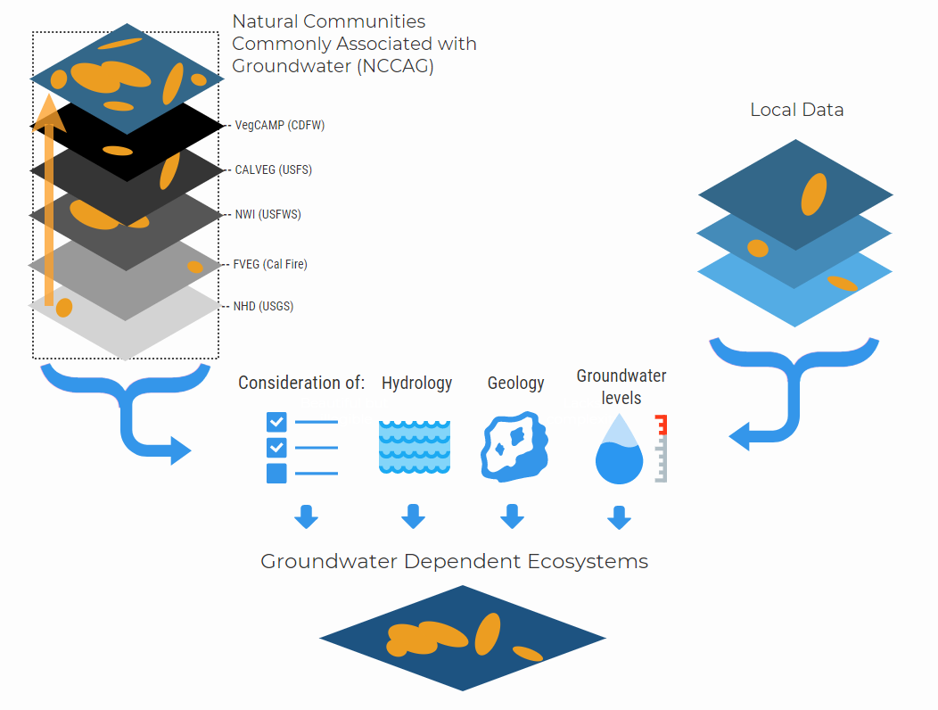
Data Sources
The publicly available data compiled into the Natural Communities dataset include several large-scale vegetation and wetland mapping efforts that conform to established State or Federal mapping standards, one large-scale seeps and springs mapping effort that is a component of the National Map, and one mapping effort that updated the locations of Mojave Desert springs. This section describes the data sources used and reasons for inclusion during the development of the Natural Communities dataset.
VegCAMP – The Vegetation Classification and Mapping Program, CDFW
Source link: https://www.wildlife.ca.gov/Data/VegCAMP
The VegCAMP dataset is considered the highest resolution data source of California vegetation mapping available and is used as the basis for the Natural Communities dataset. The purpose of VegCAMP is to maintain maps and classification of all vegetation in the State to support conservation and management decisions at the local, regional, and state levels. Fish and Game Code §1940 directed CDFW to develop and maintain a vegetation dataset for the State of California in compliance with Survey of California Vegetation (SCV) Classification and Mapping Standards (https://nrm.dfg.ca.gov/FileHandler.ashx?DocumentID=102342&inline).
Based on the SCV standard, vegetation maps consist of geospatially registered polygons which are interpreted through analysis of aerial imagery. The base imagery must meet or exceed the National Agriculture Imagery Program (NAIP) resolution standards (one-meter ground sample distance). The minimum mapping unit is usually 1 or 2 acres, but no more than 10 acres for vegetation. Wetlands are mapped to 0.25 acres. The minimum width of polygons is generally no less than 30 feet (10 meters). Once the polygons are mapped, field reconnaissance surveys are performed to match aerial photograph analysis with the actual vegetation types on the ground.
The Natural Communities dataset includes only 31 of the individual VegCAMP mapping projects and a CDFW-created composite layer of the Central Valley. In areas of overlap between the individual mapping projects, only the dataset that used the most recent aerial imagery was included in the Natural Communities dataset.
CALVEG – Classification and Assessment with Landsat Of Visible Ecological Groupings, USDA Forest Service
Source link: https://www.fs.usda.gov/detail/r5/landmanagement/resourcemanagement/?cid=stelprdb5347192
The United States Department of Agriculture (USDA) Forest Service Region 5 employs the CALVEG system to classify "existing vegetation". For classification of existing vegetation, a set of U.S. Forest Service standards and procedures has been established at the national and regional levels. The Region 5 CALVEG classification system conforms to the upper levels of the National Vegetation Classification Standard (USNVC) hierarchy as it currently exists (Federal Geographic Data Committee 2008). The USNVC sets guidelines for all federal agencies involved in this work. The CALVEG team's mission was to classify California existing vegetation communities for use in statewide resource planning considerations.
The CALVEG system maps large areas of the State with minimal bias and is supplemented with onsite field visits when appropriate. Map attributes consist of vegetation types using the CALVEG classification system and forest structural characteristics such as tree and shrub canopy cover and tree stem diameters.
The CALVEG dataset includes vegetation maps for almost 75% of California, with data available by ecoregion. The eleven CALVEG datasets were compiled for inclusion in the Natural Communities dataset, but were only used in areas not already mapped by VegCAMP due to its coarser mapping unit.
NWI V 2.0 – National Wetlands Inventory (Version 2.0), United States Fish and Wildlife Service
Source link: https://www.fws.gov/wetlands/
The purpose of NWI is to provide current, geospatially-referenced information of the status, extent, characteristics, and functions of wetland, riparian, deepwater, and related aquatic habitats in priority areas to promote the understanding and conservation of these resources. These data delineate the areal extent of wetlands and surface waters as defined by the Federal Geographic Data Committee as a National Standard (FGDC-STD-004) in 2013, adapted and modified from Cowardin et al. (1979). As part of the NWI, the USFWS has a program to map riparian vegetation in the arid regions of the United States (USFWS riparian data). The target mapping unit of the dataset is 0.5 acre.
The NWI database was used to map wetlands within the Natural Communities dataset. The NWI database was also used to map springs and seeps, but only in areas not already mapped by the National Hydrography Dataset or the Mojave Desert Springs Survey (described below). Similarly, the USFWS riparian data was only used in portions of Southern California not already mapped by VegCAMP or CALVEG data because the VegCAMP and CALVEG datasets are higher resolution than the USFWS riparian data.
FVEG – California Department of Forestry and Fire Protection, Fire and Resources Assessment Program (CALFIRE FRAP)
Source link: http://frap.fire.ca.gov/data/frapgisdata-sw-fveg_download
The FVEG dataset was developed in coordination with the CDFW VegCAMP program and the USDA Forest Service Remote Sensing Laboratory to compile a best available land cover dataset. The data cover the entire State of California. The various data sources included in FVEG were standardized by reclassifying the various vegetation types using the California Wildlife Habitat Relationships (CWHR) system classification scheme. FVEG is a gridded dataset with 30-meter cells rather than polygons. The cells were converted to polygons for use in the Natural Communities dataset where applicable.
FVEG was only used in the Natural Communities dataset in areas not already mapped by VegCAMP, CALVEG, or USFWS riparian data.
United States Geologic Survey (USGS) National Hydrography Dataset (NHD)
Source link: https://nhd.usgs.gov/
The National Hydrography Dataset (NHD), a component of The National Map, represents the water drainage network of the United States with features such as rivers, streams, canals, lakes, ponds, coastline, dams, and stream gages. This high-resolution dataset is mapped at a scale of 1:24,000 or better. The NHD contains line features, area features, and point features. For the Natural Communities dataset, the NHD was used to obtain point locations for springs and seeps. For consistency with the features included in the Natural Communities dataset, spring and seep point locations were buffered with a radius of 50 feet to create a polygon. In areas where NHD seeps and springs data overlapped with NWI wetland data, NHD data was used.
Mojave Desert Springs and Waterholes (Mojave Desert Spring Survey)
Source link: https://www.scienceforconservation.org/products/mojave-desert-spring-survey
The Mojave Desert Spring Survey identified 437 springs within the Inyo, Kern, Los Angeles, and San Bernardino county portions of the Mojave Desert that were previously mapped by other agencies and organizations. In 2015 and 2016, 312 of the springs were field inspected and the geographic coordinates were updated. For the 125 springs not field inspected, coordinates were refined using recent high-resolution imagery and/or reported coordinates used in BLM inspection reports. The refined geographic coordinates for each spring were published in a report of survey results. For the Natural Communities dataset, the geographic locations included in the report were converted to a shapefile of point locations. For consistency with the features included in the Natural Communities dataset, the point locations were buffered with a radius of 50 feet to create a polygon.
The Mojave Desert Spring Survey dataset is included in the Natural Communities dataset in addition to the NHD and has the same order of preference as the NHD.
Processing & Quality Assurance
After the vegetation, wetland, seeps, and springs data described above were compiled into the Natural Communities dataset, data were screened to exclude vegetation and wetland types less likely to be associated with groundwater and retain types commonly associated with groundwater. The screening, which was conducted by DWR, CDFW and TNC, was based on the criteria described below and in Klausmeyer et al. 2018.
Vegetation Layer
All water features were removed from the source vegetation datasets since water features are mapped in higher detail by NWI. The remaining vegetation alliances (VegCamp), vegetation types (CALVEG), and habitat types (FVEG) were classified by ecoregion and assigned a dominant species, where possible, based on vegetation alliance descriptions, field observations, and/or publications.
Subject matter experts then reviewed the combination of ecoregion location and dominant species names against published lists of phreatophytes to determine (1) if the dominant species was a listed phreatophyte, and if so, (2) was likely to be phreatophytic in that ecoregion or likely to rely on surface water, precipitation, or other non-groundwater sources. If multiple dominant species names were listed for a particular vegetation type, the first phreatophytic species listed was selected to represent the vegetation type. Vegetation alliances, vegetation types, and habitat types determined to be phreatophytic were retained.
For the more general vegetation types that did not have one dominant species, the source metadata and associated reports were reviewed to determine all dominant species associated with that vegetation type. If more than half of the dominant species consisted of phreatophytes, the vegetation type was retained. Broad vegetation categories that lacked supporting descriptions of associated species were not assigned a dominant species and further screened for association with highly disturbed or managed conditions, or likelihood of dependence on non-groundwater sources. Riparian vegetation is considered to be phreatophytic; all USFWS Riparian Data were therefore retained in areas not already mapped by VegCAMP and CALVEG.
Additional screening was then conducted to retain source features of certain vegetation types located along alluvial floodplains, as well as to remove those located on hillslopes where they are more likely to rely on surface water, rainfall, and fog drip than on groundwater. The hillslope vegetation types include those with the dominant species Carex barbarae, Juglans californica, Picea sitchensis, Pinus contorta, Quercus agrifolia, or Sequoia sempervirens, as well as the “Desert Mixed Wash Shrub” vegetation type. The US Environmental Protection Agency (2013) maps of active river areas were used to clip these vegetation types to remove hillslope areas. All mapped “Playa” features were also screened using recent high-resolution satellite imagery to remove source features without visible vegetation stands.
Wetlands Layer
All wetlands mapped in NWI were first screened based on their wetland classification. Marine and estuarine wetland types were excluded because the ocean is their main source of water. Although some estuarine habitats have documented groundwater inputs, estuarine wetlands were removed due to the level of uncertainty about the amount of groundwater input. All lacustrine wetlands were retained. Palustrine wetlands were also retained, with the exception of vernal pools that are not dependent on groundwater. Vernal pool complexes were screened based on specific wetland codes. Riverine wetlands representing perennial rivers and tidally-influenced freshwater rivers were retained, but intermittent streams were excluded due to uncertainty about which ones receive groundwater input. These retained wetland types were further screened to remove human modified wetlands. Human modified wetlands were identified with modifiers such as ‘Farmed’, ‘Diked/Impounded’, and ‘Artificially Flooded’.
Additional screening of the retained wetland types was conducted based on their water regime description. The remaining wetlands with water regimes of continuously or seasonally saturated; intermittently exposed; or permanently, semi-permanently, or seasonally flooded were retained. Wetlands with water regimes of intermittently, temporarily, or regularly flooded were excluded. All seeps and springs, which are a surface expression of groundwater, were retained.
Compiled Natural Communities Dataset
Each data source was clipped to the Bulletin 118 Groundwater Basin boundaries (i08_B118_CA_GroundwaterBasins) to remove polygons mapped outside of the groundwater basin boundaries. Any source features underlying agricultural areas identified in the 2014 statewide Crop Mapping data set released in 2017 (i15_Crop_Mapping_2014) were also removed from the Natural Communities dataset. With the exception of narrow riparian corridors, any source features underlying urban areas identified in a compilation of DWR County Land Use Surveys beginning in 2000 through 2014 and the 2014 US Department of Agriculture Cropland Data Layer were removed from Natural Communities dataset. In narrow riparian corridors located in mapped urban areas, source features underlying urban areas within 100 meters of rivers and waterbodies (as mapped in the NHDPlus V2 dataset) were retained.
Additional cursory screening was conducted for 135 individual groundwater basins. The purpose of the additional screening was to visually identify inaccuracies in the datasets. Natural communities that coincide with some of the following areas were removed during this review:
- Irrigated agricultural areas not captured in previous filtering steps
- Engineered water supply canals, aqueducts, ditches, or other conveyance facilities
- Reservoirs, stock ponds, and lakes engineered for water storage
- Heavily disturbed areas, such as quarries, gravel mining operations, and oil fields
- Managed recharge facilities
- Areas no longer in existence due to land use changes
- Areas where depth to groundwater is known to be too great to support phreatophytic vegetation
- Mapping artifacts
Some of the additional processing steps altered the geometry of the vegetation and wetland polygons to make them smaller than the minimum mapping unit for the source data set. All features remaining in the Natural Communities dataset that were smaller than the minimum mapping unit of the respective data source were removed. If no minimum mapping unit was published in the metadata or associated reports for the source data, a minimum mapping unit of 1,000 m2 (~1/4 acre) was applied. In some cases, the source data included vegetation or wetland features smaller than the published minimum mapping unit. These features were retained in the Natural Communities dataset if they were identical to the polygon in the source dataset (i.e. they had not been modified by the processing steps listed above).
Applicability of the Natural Communities Dataset to GSP Development
The Natural Communities dataset is provided by DWR as a reference dataset and potential starting point for the identification of GDEs in groundwater basins. The Natural Communities dataset and its source data can be reviewed by GSAs, stakeholders, and their consultants using local information and experience related to the validity of mapped features and understanding of local surface water hydrology, groundwater conditions, and geology as illustrated below. Appendix A further discusses the requirements of SGMA and the GSP Regulations related to GDEs, environmental users of groundwater, and local habitat.
Note
The Natural Communities dataset does not prove or make any claim about the nature and/or extent of ecosystem groundwater dependence for any mapped location. Positive identification of a GDE requires understanding of the land use, groundwater levels, hydrology, and geology of an area, which is not within the scope or purpose of the dataset. The Natural Communities dataset and web viewer is not intended to be used for verifying the accuracy of the GSAs’ identified GDEs.
References
California Department of Fish and Wildlife. (2017). Vegetation Classification and Mapping Program. Retrieved April 14, 2017, from https://www.wildlife.ca.gov/Data/VegCAMP
California Department of Forestry and Fire Protection. (2015). Fire and Resource Assessment Program (FRAP) Vegetation (FVEG15_1). Sacramento, California. Retrieved from http://frap.fire.ca.gov/data/frapgisdata-sw-fveg_download
California Department of Water Resources. (2003). Bulletin 118 - California’s Groundwater. Retrieved from https://data.cnra.ca.gov/dataset/ca-bulletin-118-groundwater-basins
California Department of Water Resources. (2016). Bulletin 118, Interim Update 2016 - California’s Groundwater, Working Toward Sustainability. Sacramento, California. Retrieved from https://www.water.ca.gov/-/media/DWR-Website/Web-Pages/Programs/Groundwater-Management/Bulletin-118/Files/Statewide-Reports/Bulletin_118_Interim_Update_2016.pdf
California Department of Water Resources. (2017). Statewide Urban Land Use (Unpublished). Sacramento, California. Cowardin, L. M., Carter, V., Golet, F. C., & LaRoe, E. T. (1979). Classification of wetlands and deepwater habitats of the United States. U.S. Fish and Wildlife Service. FWS/OBS-79/31. Washington D.C. Retrieved from https://www.fws.gov/wetlands/Documents/Classification-of-Wetlands-and-Deepwater-Habitats-of-the-United-States.pdf
California Department of Water Resources, Land IQ (2017). Statewide Crop Mapping 2014. California Department of Water Resources. Retrieved from https://gis.water.ca.gov/app/CADWRLandUseViewer/
Federal Geographic Data Committee. (2013). Classification of wetlands and deepwater habitats of the United States. FGDC-STD-004-2013. Second Edition. Washington D.C. Retrieved from https://www.fws.gov/wetlands/Documents/Classification-of-Wetlands-and-Deepwater-Habitats-of-the-United-States-2013.pdf
Federal Geographic Data Committee. (2008). National Vegetation Classification Standard, Version 2. Vegetation Subcommittee. Retrieved from https://www.fgdc.gov/standards/projects/FGDC-standards-projects/vegetation/NVCS_V2_FINAL_2008-02.pdf
Klausmeyer, K., Howard J., Keeler-Wolf T., Davis-Fadtke K., Hull R., and Lyons A. (2018). Mapping Indicators of Groundwater dependent ecosystems in California https://groundwaterresourcehub.org/gde-tools/mapping-indicators-of-gdes/
Lichvar, R., & Dixon, L. (2007). Wetland Plants of Specialized Habitats in the Arid West. Hanover, NH. Retrieved from http://www.dtic.mil/get-tr-doc/pdf?AD=ADA469459
Mathie, A. M., Welborn, T. L., Susong, D. D., & Tumbusch, M. L. (2011). Phreatophytic Land-Cover Map of the Northern and Central Great Basin Ecoregion: Ecoregion: California, Idaho, Nevada, Utah, Oregon, and Wyoming. U.S. Geological Survey Scientific Investigations Map 3169. Reston, Viginia. Retrieved from http://pubs.usgs.gov/sim/3169
Robinson, T. W. (1958). Phreatophytes: U.S. Geological Survey Water Supply Paper 1423. Washington, D.C. Retrieved from https://pubs.usgs.gov/wsp/1423/report.pdf
U.S. Environmental Protection Agency, U.S. Geological Survey, & Horizon Systems. (2017). NHDPlus Version 2. Retrieved from http://www.horizon-systems.com/NHDPlus/NHDPlusV2_home.php
U.S. Fish and Wildlife Service. (2009). A System for Mapping Riparian Areas in the Western United States. Retrieved from https://www.fws.gov/Wetlands/Documents/A-System-for-Mapping-Riparian-Areas-In-The-Western-United-States-2009.pdf
U.S. Fish and Wildlife Service. (2016). National Wetland Inventory, Version 2. California Wetlands. Washington D.C. Retrieved from https://www.fws.gov/wetlands/Downloads/State/CA_wetlands.zip
U.S. Forest Service. (2016). Existing Vegetation - CALVEG. McClellan, CA. Retrieved from http://www.fs.usda.gov/detail/r5/landmanagement/resourcemanagement/?cid=stelprdb5347192
U.S. Geological Survey. (2016). National Hydrography Dataset, High Resolution, v220. Washington D.C. Retrieved from ftp://nhdftp.usgs.gov/DataSets/Staged/States/FileGDB/HighResolution/NHDH_CA_931v220.zip